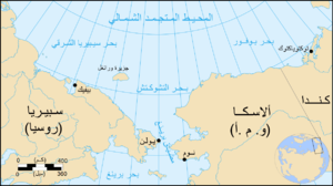
Bering Strait
 |
| عربی زپان |


![[2]](http://www.wall-maps.com/World/PetersProjection-over.gif)
The Bering Strait (Russian: Берингов пролив, Beringov proliv, Yupik: Imakpik[1][2]) is a strait82 kilometres (51 mi; 44 nmi) wide between Cape Dezhnev, Chukchi Peninsula, Russia, the easternmost point (169° 43' W) of the Asian continent and Cape Prince of Wales, Alaska, USA, the westernmost point (168° 05' W) of the North American continent. Named after Vitus Bering, a Russian explorer born in Denmark, it lies slightly south of the polar circle at approximately 65° 40' N latitude, with the present US-Russia east-west boundary, agreed to only by the USA,[citation needed] at 168° 58' 37" W.
The Strait has been the subject of scientific speculation that humans migrated from Asia to North America across a land bridge known as Beringia when lower ocean levels – perhaps a result of glaciers locking up vast amounts of water – exposed a wide stretch of the sea floor,[3]both at the present strait and in the shallow sea north and south of it. This view of how paleo-indians entered America has been the dominant one for several decades and continues to be the most accepted one.
The name of the sea containing the strait is sometimes spelled Behring in older books.
As of 2012, the Russian coast of the Bering Strait was a closed military zone. Unauthorized travelers who arrive on shore after crossing the strait, even those with visas, may be arrested, imprisoned briefly, and deported.[4]
No comments:
Post a Comment